Track N Trail - Hunting & Maps
4.4 93.00 Reviews
Analysis By AppCompare
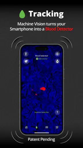
I approached Track N Trail as a practical sports app rather than as a simple map viewer. Its purpose is to help turn a phone into a hunting-focused tracking tool, with land maps included in the experience. That combination makes it interesting for people who spend time outdoors and want their phone to support decisions in the field, but it also means the app needs to be judged by more than its store summary. The important question is whether its map-and-tracking approach suits the way you actually prepare, travel and record activity.
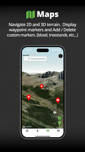
After using it, my view is fairly clear: this is most appealing when you want one hunting-oriented place to look at land information and follow your movement. It is less convincing as a universal replacement for every outdoor tool. The best choice depends on whether you value a focused hunting workflow over the broader navigation features found in general mapping apps, dedicated GPS devices or other sports trackers.
How I would decide whether this hunting app fits
Start with the kind of outdoor problem you need to solve
I would not begin by asking whether a map app is “good” in the abstract. I would ask what I need it to do on a normal outing. If the goal is to understand where I am in relation to land boundaries, plan a route before leaving, and keep a phone-based record of movement, Track N Trail has a sensible focus. Its identity is clearly tied to hunting and land awareness, not to running, cycling or casual city navigation.
That focus matters because a general map can show roads and terrain while still feeling awkward for a hunting trip. A hunting-oriented interface can reduce the amount of translation I have to do between what I see on screen and what I need to decide outdoors. I can think in terms of access, position and land context instead of treating the outing like an ordinary car journey.
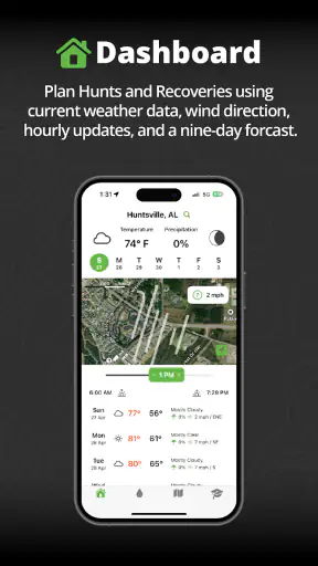
At the same time, I would separate map usefulness from field safety. A phone is convenient, but it is still a phone. Battery level, visibility, weather, reception and the physical durability of the device all affect the experience. I would prepare the route before setting out, carry a backup power source, and avoid treating the app as my only means of orientation in unfamiliar country.
What to test before relying on it
My first practical test would be done at home, not at the trailhead. I would open the relevant land area, examine how easily I can identify the places I care about, and rehearse the gestures needed to move around the map. That small preparation step reveals whether the app feels natural enough to use with cold hands, limited light or attention divided between the screen and the surroundings.
I would also try a short local walk before using it for a longer hunting day. The point is not merely to see whether the phone shows my position. I would check whether I can understand that position quickly, whether the map remains readable when zoomed out, and whether the tracking view helps me remember where I have already been. Those details determine whether the app saves effort or creates another task.
One useful habit is to create a simple pre-trip routine: inspect the intended area, note the main access point, check the phone’s charge, and take a screenshot or written note of the basic plan. I would not depend on a screenshot for live navigation, but it provides a useful reference if I need to close the app or conserve power. This is the kind of preparation that makes a phone-based tool more dependable without pretending it has replaced outdoor judgment.
The audience it serves best
I see the strongest fit for hunters who already carry a smartphone and want a purpose-built starting point for land maps and movement tracking. It can also suit someone moving from paper maps to digital planning, provided that person is willing to learn the interface and build a backup habit. The app’s Everyone content rating makes it broadly approachable from an age-classification perspective, although the practical subject matter is naturally aimed at outdoor users rather than every phone owner.
It is less suitable for someone looking for a complete fitness platform, detailed training analysis or a social sports community. The app belongs to the sports category, but that label should not make a runner or cyclist assume it will work like a workout tracker. Its value comes from hunting context and land awareness, not from turning every outdoor activity into a set of exercise metrics.
Where the focused approach wins
The main strength is concentration. Instead of starting with a broad navigation product and trying to adapt it to hunting, I can begin with an app designed around the relationship between movement and land. That makes it easier to imagine a workflow in which I review an area before leaving, use the phone to maintain orientation, and look back at the outing afterward.
I also like the idea of keeping planning and field reference close together. Switching between a general map, a notes app and a separate tracking tool can be tiring, especially when the screen is small and the conditions are not comfortable. A focused app has the potential to reduce that switching. Even when it does not replace every other tool, having one central view can make the outing feel less fragmented.
A less obvious benefit is the way a dedicated hunting app can encourage better preparation. When the map is the center of the workflow, I am more likely to inspect the area in advance rather than improvising every decision once I arrive. I can think about entry, movement and return before the phone becomes essential. That is a behavioral advantage, not a flashy feature, but it is one of the reasons I would consider this type of app.
Everyday use: preparing for a morning in the field
Imagine I am planning a morning outing in an area I know only moderately well. The night before, I open Track N Trail and study the land map instead of waiting until I am standing beside the vehicle. I identify the general area I want to approach, look at the surrounding roads and terrain shown by the map, and decide where I want to begin. I then make a simple mental plan for returning, rather than assuming I will remember every turn.
At the start of the outing, I use the phone as a reference rather than staring at it continuously. I check my position at sensible intervals, keep the device secure, and pay attention to the actual surroundings. If I change direction, the tracking record can help me understand the route I have already taken. On the way back, that history is more useful than a vague memory of which opening or crossing I passed earlier.
This scenario shows both the app’s value and its limit. It can support awareness, but it does not make decisions for me. I still need to interpret the land, respect access rules, manage the phone and use common sense. The app works best as an aid that reduces uncertainty, not as an automatic guide that removes responsibility.
Three practical insights that are easy to miss
First, I would use the tracking function as a review tool, not only as a way to find my current position. After a trip, the route can help me remember how long a section felt, where I changed direction and which approach was more comfortable. That turns a single outing into information for the next one. Even a basic record can improve planning when I compare what I expected with what actually happened.
Second, I would avoid zooming and panning constantly while moving. That sounds obvious, but it is an important trade-off on a phone. Frequent map adjustments consume attention and can make the outing feel like a screen-management exercise. I prefer to set the view before moving, check it at deliberate points, and let the physical environment remain the primary source of awareness.
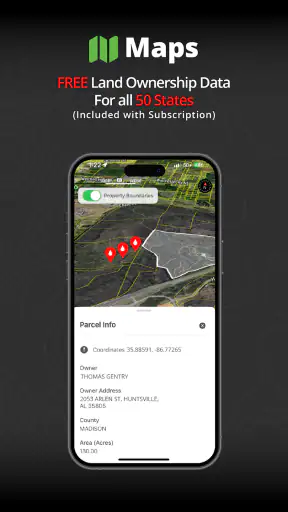
Third, I would treat the land map as a planning layer rather than as a legal conclusion. A map can help me understand an area, but I would still verify current access requirements, local rules and any restrictions through the appropriate official sources. This is especially important when a boundary or route affects where I may lawfully travel. The app is useful for orientation; it should not be the only authority for permissions.
Friction I noticed in the phone-first format
The first limitation is inherent in using a phone outdoors. A large, bright screen is helpful for map reading, but it can be awkward in direct sunlight and inconvenient when I need both hands for equipment or movement. A small screen also makes broad-area planning less comfortable than it is on a tablet, computer or printed map. I would happily use the phone in the field, but I would do more detailed preparation on a larger display when possible.
The second limitation is dependence on personal preparation. A dedicated handheld GPS device often feels more purpose-built for rough outdoor use, while a phone requires me to think about protection, charge and how I will access it. That does not make Track N Trail a poor choice, but it raises the cost of using it responsibly. Someone who wants to leave home with no backup plan may be disappointed by any phone-based solution.
The third limitation is that a focused hunting tool may feel narrow outside its intended setting. If I want commuting directions, restaurant searches, live traffic or broad travel planning, I would reach for a conventional maps app. If I want structured exercise statistics, I would choose a fitness product. Track N Trail makes more sense when hunting and land maps are the center of the task.
How it compares with the usual alternatives
Compared with a general mapping app, Track N Trail’s advantage is relevance. A general service is usually better for roads, addresses and everyday travel, but it may require more effort to adapt to a hunting outing. I would choose the general option when I am driving to a location or navigating ordinary public streets. I would choose Track N Trail when the land itself is the main subject of the trip.
Compared with paper maps, the app offers a more immediate relationship between my phone and my current position. Paper remains valuable as a silent, battery-free backup and as a broad planning surface. I would not discard it entirely. In practice, the strongest combination for a serious outing may be digital convenience in hand and a simple backup plan stored separately.
Compared with a dedicated GPS unit, the phone is easier to adopt because I already carry it and do not need a second screen for basic use. A dedicated device may be preferable for people who prioritize ruggedness, long field sessions or hardware built specifically for navigation. The decision is less about which category is universally superior and more about whether convenience or specialized durability matters more in my routine.
Compared with a general sports tracker, this app appears better aligned with land-based outdoor activity than with performance training. I would not select it to analyze pace, workouts or athletic progress. I would select it to support route awareness and hunting preparation. That distinction prevents a lot of disappointment and makes the purchase decision much clearer.
Free entry, paid expansion and the cost of switching
The app is free to install, which makes trying the basic experience relatively easy. That is a meaningful advantage for anyone unsure whether a hunting map workflow will fit. I can test the interface, take a short local outing and decide whether the map presentation makes sense before committing to a different tool or a dedicated device.
There are in-app purchases priced from around thirty dollars to around fifty dollars per item. That changes the decision for users who need more than the free starting point. I would not buy an expansion simply because the app is interesting; I would first identify the exact problem I am trying to solve and confirm that the paid option addresses it. The sensible approach is to begin with a real route and a clear use case, then judge whether the additional cost saves enough time or uncertainty to justify itself.
The cost of switching is not only financial. If I move from a familiar mapping system, I may need to rebuild habits, learn a different map layout and adjust how I record trips. My recommendation is to run both approaches during a low-risk outing rather than abandoning the old method immediately. Keep the usual map or backup available, use Track N Trail for the same journey, and compare how quickly each one answers the questions I actually have outdoors.
What the current app profile suggests
Track N Trail comes from Track'n Trail and is currently at version 1.4.1, with a minimum operating system requirement of Android 7.0. It has a 4.4 average from over five hundred ratings and more than fifty thousand installs, which suggests that it has found a real audience without being so widespread that every outdoor workflow is already standardized around it. I read those figures as a reason to investigate, not as proof that it will suit every region or every hunting style.
The app was released on June 4, 2025, and its free pricing lowers the barrier to a first test. The age classification is Everyone, while the subject matter still makes it a specialized sports utility rather than a general family app. I would also remember that the paid items range from about thirty dollars to about fifty dollars, so a serious evaluation should include the full cost of the features I expect to use, not just the free download.
One practical question many users have is whether an older Android phone can run it. The stated minimum is Android 7.0, so compatibility begins there, but compatibility alone does not guarantee a comfortable field experience. Screen brightness, battery health, storage and physical protection may matter just as much. I would test the actual phone I plan to carry, especially if it is an older model.
Who should skip it
I would skip Track N Trail if my main need is city navigation, road-trip planning or a polished fitness dashboard. Those tasks are better served by categories built around them. I would also hesitate if I rarely go outdoors and have no interest in learning a map-based workflow, because a focused hunting app will add little value to occasional casual use.
I would be cautious if I expect the app to replace official land information, personal navigation skills or a reliable backup. No app should be the sole basis for access decisions or safety-critical travel. Likewise, if I spend long periods far from power and want hardware designed specifically for that environment, a dedicated GPS device may be the better investment even if it costs more initially.
My recommendation after weighing the trade-offs
I recommend trying Track N Trail if you hunt or spend substantial time exploring land and want a phone-based combination of tracking and maps. Its strongest case is not that it does everything. Its strongest case is that it gives a hunting-focused workflow a clear place on the phone many people already carry. The free entry point makes a careful trial reasonable, while the paid items mean I would evaluate expansion value before spending.
My advice is to test it in three stages: plan a familiar outing, use it on a short route with a backup, and then review whether it genuinely reduced map switching or confusion. If it helps you understand land and movement more quickly, it may earn a permanent place in your kit. If it feels like a generic map with extra steps, stay with the alternative that already works for you.
For me, the deciding point is purpose. Choose it for hunting-oriented land awareness, not for general navigation or fitness tracking. Used with sensible preparation, a backup plan and realistic expectations about phone limitations, it can be a useful companion. If your priorities are rugged hardware, formal training analysis or everyday directions, another category will likely fit better. That makes Track N Trail a focused recommendation rather than an all-purpose one—and in this case, that focus is exactly what gives it value.
FAQ
What is Track N Trail - Hunting & Maps used for?
Track N Trail - Hunting & Maps is designed to help hunters plan, navigate, and record outdoor trips. It can provide mapping tools, location tracking, waypoints, route recording, and access to hunting-related information, depending on the selected features and subscription. Before downloading, users should check whether the available maps and hunting data cover their region and match their specific outdoor needs.
Does Track N Trail work without an internet connection?
The app may support offline use when maps or relevant content are downloaded in advance, which is particularly useful in remote hunting areas with weak or unavailable mobile coverage. However, not every feature necessarily works offline. Users should prepare their routes, save map areas, and verify that GPS tracking and downloaded data function correctly before leaving home, rather than relying on a live connection in the field.
Is Track N Trail - Hunting & Maps free to download?
The application may be available to install at no initial cost, but some advanced tools, map layers, hunting information, or premium services can require an in-app purchase or subscription. Pricing and included features may vary by platform, country, and current offer. It is worth reviewing the store listing and subscription terms carefully before starting a trial or entering payment details.
How accurate are the maps and hunting boundaries in the app?
Map accuracy depends on the data provider, the user’s location, GPS reception, and how recently local boundaries or land information were updated. Track N Trail can be a useful planning and navigation aid, but it should not be treated as the sole legal authority. Hunters should confirm regulations, property access, season dates, and official boundaries with local wildlife agencies and landowners.
Does the app protect my location and hunting activity data?
Because a navigation and tracking app can collect location information, users should review its privacy policy and permission requests before using it. Check whether location data is stored on the device, synchronized with an account, or shared through social and cloud features. Only grant permissions that are necessary, and avoid publicly sharing sensitive hunting spots or routes if privacy is important to you.
Pros
- Offline maps help maintain navigation in areas with weak or no signal.
- Hunting-focused map layers make scouting and route planning more practical.
- GPS tracking records routes and helps monitor distance and movement.
- Location tools can improve awareness of property boundaries and terrain.
- Useful for organizing hunting trips
- waypoints
- and important field locations.
Cons
- Some advanced map layers or features may require a paid subscription.
- Offline map downloads can consume considerable storage space.
- GPS use may drain the phone battery quickly during long outings.
- Map accuracy and property data can vary by region or update frequency.
- The app may take time to learn if you are unfamiliar with mapping tools.